If you're new here, you may want to subscribe to my RSS feed. Thanks for visiting!
By Daisy Luther
The warnings may be coming too late for the eastern United States as Hurricane Maria pushes Northwest. Whether Maria will be a tropical storm or hurricane when she hits North Carolina remains to be seen, but it’s almost certain that some kind of major storm will strike tomorrow with direct force. Unlike Harvey and Irma, the third hurricane in a month won’t have a week-long warning period for people to get prepared. Meteorologists have been uncertain up until now whether the storm will affect the coast or head harmlessly out to sea and have said that a hit is unlikely up until now.
To keep up to date, be sure and bookmark my site, Preppers Daily News. The middle column is currently dedicated to hurricane news.
The predictions for Hurricane Maria
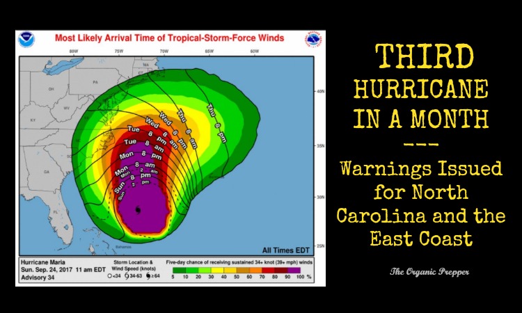
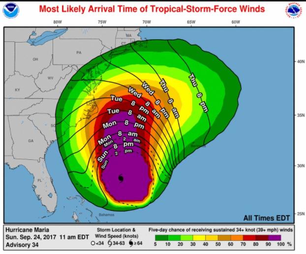
The good thing is that Maria has lost power after absolutely devastating Dominica and Puerto Rico. The eye is predicted to remain about 10 miles of shore, so we may not sustain a direct hit, but the storm will be close enough to cause serious damage and flooding. This map from the National Weather Service shows us when and where the winds are expected to arrive.
(photo credit)
Currently, the National Weather Service says Maria has weakened to a tropical storm. Keep in mind that a tropical storm can still have winds up to 73 miles per hour and life-threatening storm surges.
Maria is a large cyclone, so even if it weakens to a tropical storm
and remains well offshore it is expected to bring tropical storm
conditions to portions of the North Carolina coast during the next
couple of days.KEY MESSAGES:
1. Maria is forecast to continue moving northward, paralleling the
U.S. east coast, and it is likely that some direct impacts will
occur along portions of the coast beginning Tuesday. A Tropical
Storm Warning has been issued for a portion of the coast of North
Carolina.2. Storm surge flooding especially along the sound side of the
North Carolina Outer Banks is possible beginning Tuesday, and a
Storm Surge Watch has been issued for a portion of the North
Carolina Outer Banks.3. Swells from Maria are increasing along the coast of the
southeastern United States and are expected to reach the Mid-
Atlantic coast today. These swells will likely cause dangerous surf
and rip currents at beaches in these areas through much of the
week. For more information, please monitor information from your
local National Weather Service office at www.weather.gov.FORECAST POSITIONS AND MAX WINDS
INIT 25/0900Z 30.6N 73.0W 70 KT 80 MPH
12H 25/1800Z 31.4N 73.2W 70 KT 80 MPH
24H 26/0600Z 32.5N 73.3W 65 KT 75 MPH
36H 26/1800Z 33.5N 73.3W 65 KT 75 MPH
48H 27/0600Z 34.3N 73.2W 60 KT 70 MPH
72H 28/0600Z 35.5N 72.0W 60 KT 70 MPH
96H 29/0600Z 37.0N 66.5W 60 KT 70 MPH
120H 30/0600Z 40.0N 56.5W 60 KT 70 MPH(source)
A five-day tracking model shows Maria retaining hurricane force winds through Friday, at which point the storm is expected to head east and out to sea.
We’re already seeing effects from the third hurricane in a month
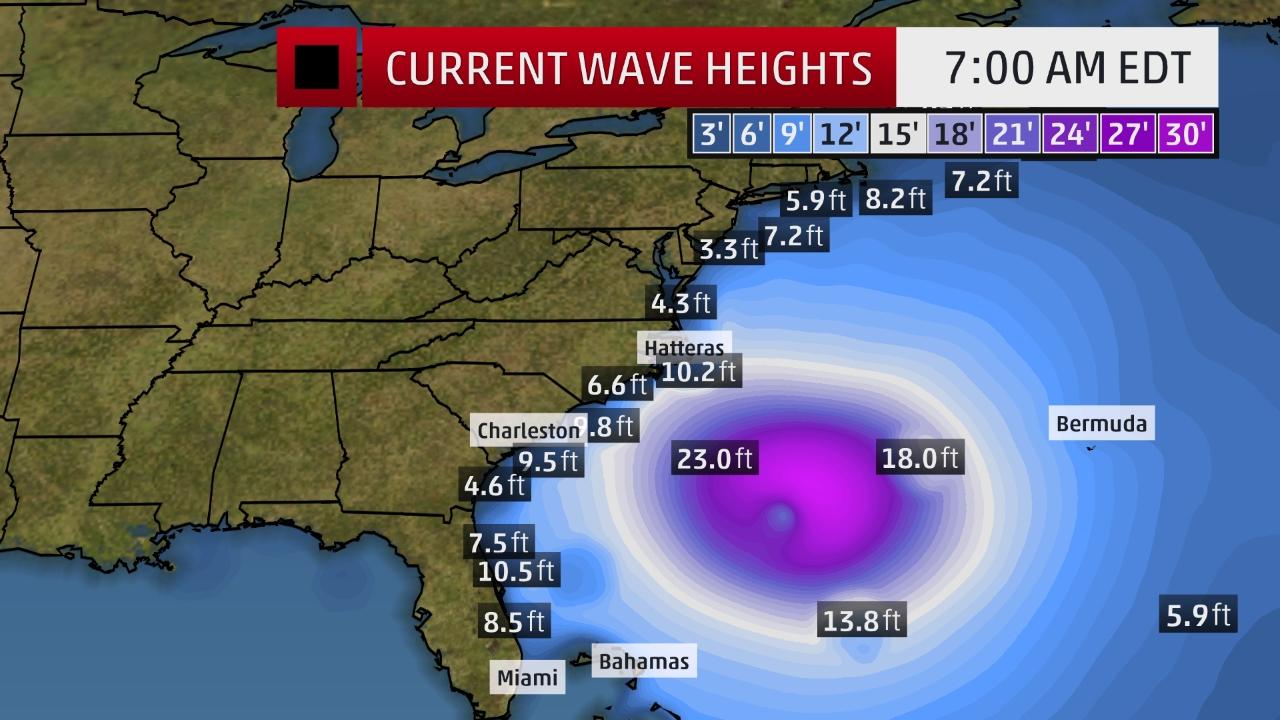
Even though Hurricane Maria is still several hundred miles away from the coast, the storm is already stirring up high winds and dangerous surf. There were 25 rescues in the Carolinas and 35 rescues as far north as New Jersey this weekend due to treacherous seas. (source) Waves are already significantly higher than normal.
We can expect to see effects from Maria all the way up the coast to Massachusetts, with particular force in the Carolinas and Virginia.
Hurricane Maria is not done yet! Please keep watching especially along the East Coast – Cape Hatteras to Norfolk.https://t.co/g6v4CRlak2 pic.twitter.com/aJ7BZNbDg3
— The Weather Channel (@weatherchannel) September 23, 2017
Get prepared.
I strongly suggest that anyone in coastal regions focus on preparing. Hopefully, this will be mild in comparison to Hurricanes Harvey and Irma, but projections have been off regarding this storm, so I would be ready for the worst. (Go here to learn more about preparing for a hurricane.) Be ready for high winds, power outages, and flooding. With the lack of warning, you may not have time to evacuate. (The barrier islands only have one road out.) If you end up being stuck in the storm zone, here are some tips for surviving the hurricane.
Keep in mind that FEMA is stretched incredibly thin, what with providing aid to Texas, Florida, the US Virgin Islands, and Puerto Rico. At some point, federal funds are going to run out, and when that happens, aid will not be arriving. If you’re in the danger zone, you must plan to be on your own during this disastrous season.
How this hurricane season compares to previous ones
So far, this hurricane season is the second costliest in US history.
Hurricanes Harvey and Irma are expected to cost the U.S. between $150 and $200 billion in combined property damage, according to Moody’s Analytics. The higher figure would make this season the second costliest to date, just behind 2005, when Hurricanes Katrina, Dennis and Cindy left behind $211 billion in damage, according to the National Hurricane Center.
But with a month of peak hurricane season still ahead of us, more storms could place 2017 atop the list of costliest seasons. (source)
Bloomberg has a different financial assessment, as it figures in the damage to the islands that are our territories. according to this quote:
This has been a particularly potent hurricane season for the United States and the surrounding islands. Three Category 4 hurricanes have hit the nation since Hurricane Harvey made landfall in Texas on Aug. 25. Bloomberg reported that collectively they have caused an estimated $170 billion in damages. When the massive damage in the Caribbean is taken into consideration, that number jumps to an astounding $300 billion, according to Bloomberg. (source)
But it’s far from the deadliest, in fact, ranking 17th on that list with 103 deaths in America. Improved forecasting is credited with saving many lives.
The deadliest natural disaster in U.S. history is also the most fatal hurricane to date. In 1900, inaccurate predictions, combined with poor warning systems, left Galveston, Texas vulnerable to a hurricane that killed between 6,000 and 12,000 people.
Twenty-eight years later, an estimated 2,500 people drowned when a Category 4 hurricane caused Lake Okeechobee in Florida to overflow, deluging the surrounding area with 10-to-15-foot floods.
The 10 deadliest hurricane seasons include only one from within the past 50 years: 2005, when Hurricane Katrina overwhelmed the levees in New Orleans and inundated the city, killing more than 1,000 people. (source)
So far, Maria has defied many predictions, so you may not know it’s coming until it’s nearly there. Get prepared for a long-term power outage, stay watchful, and stay safe.





One Response
It just seems like the US can’t get a break. Hopefully the president and congress will budget for these major events by making deductions to not strictly necessary areas (when I say ‘not strictly necessary’, I mean areas such as cutting the defence budget, not education, the IRS, social security or other fields necessary for the continued operation of the US).