If you're new here, you may want to subscribe to my RSS feed. Thanks for visiting!
Author of Be Ready for Anything and Bloom Where You’re Planted online course
Hurricane Dorian had been headed straight for Florida as a potential Category 4 hurricane, but this morning, things have changed. The hurricane has picked up even more power and is now a Category 5, and the direction has shifted, putting South Carolina directly in Dorian’s crosshairs.
Zero Hedge reports:
As of Saturday afternoon, Dorian was sporting an unusually wide ‘cone of uncertainty,’ which is making it especially difficult to track, according to the NYT.
According to the NHC, since Dorian has slowed down and could now turn northward just before making landfall in the Continental US, “it is too soon to determine when or where the highest surge and winds could occur.” As a result, “the risk of strong winds and dangerous storm surge is increasing along the coasts of Georgia, South Carolina and North Carolina during the middle of next week.” (source)
People on the entire East Coast have been warned to get prepared as it seems that this hurricane has become more and more unpredictable.
Hurricane Dorian is currently near the Bahamas
Dorian is expected to strike the Bahamas today and tomorrow.
Hurricane Dorian now has maximum sustained winds of 160 mph, according to the National Hurricane Center. This would put the storm in the highest category on the Saffir-Simpson Hurricane Wind Scale.
Dorian will be capable of catastrophic damage as it tracks towards the Bahamas today into tomorrow…
…NHC said the most severe weather of the hurricane, known as the eyewall, is about to hit Abaco islands in the Bahamas. (source)
The hurricane is not expected to lose power over the Bahamas as it heads toward the eastern coast of the US.
Florida is still not out of the woods.
Although the hurricane appears to have shifted north, Floridians shouldn’t get too comfortable.
Even though the storm’s path has shifted, Florida residents should still prepare for the worst. That includes “possible extensive power outages,” according to a spokesman for Florida Power & Light. The utility has brought in about 18,000 workers in the state, and crews are staging at areas expected to be among the hardest hit, according to CNN.
Even if the storm doesn’t directly hit Florida, it could still cause life-threatening flooding, Gov. Ron DeSantis warned. And “if it bumps just a little west, you’re still looking at really, really significant impacts,” he warned. (source)
So where is the hurricane going to hit?
In reality, nobody knows where Hurricane Dorian will make landfall.
Hurricane Dorian has been threatening to make its way to the US mainland, but there is still much uncertainty on when and where it will make landfall.
The storm had been projected to reach Florida for Labor Day Weekend. But current forecasts have it turning north Monday evening. The storm is predicted to ride along the US east coast along Florida, Georgia and the Carolinas, Shackelford said.
But will it make landfall on any of those states?
It is not yet clear. Many models show the storm staying just off Florida’s coast Tuesday and then skirting the coasts of Georgia and North and South Carolina.
Still, a major hurricane hovering just off a US coast could cause life-threatening damage. (source)
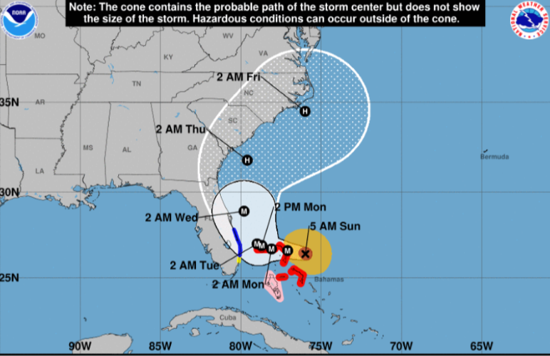
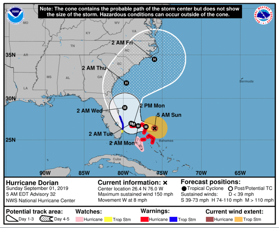
And this forecast map from the NOAA shows the potential for damaging winds and flooding as far north as Virginia.
Monday and Tuesday will tell the tale, as that is when Dorian is expected to make landfall…somewhere.
How should you get prepared?
If you’re anywhere on the southern end of the East Coast, I strongly urge you to get prepared. This hurricane has surprised forecasters twice now, so it isn’t a stretch of the imagination to believe it may surprise them again.
This round-up has 10 articles that will help you get prepped in a hurry if you weren’t expecting a visit from Dorian. And this article has some last-minute shopping ideas when the shelves are bare.
If your local stores have run out of bottled water, don’t despair. Purchase containers and fill them up with tap water. If you have a water bob, you’ll want to get it ready to pop into your tub. If you don’t have on, scrub your bathtub down and rinse it well, then be ready to fill it with water as the storm draws near. Fill every container in your house with water.
Freeze some of your water to help keep your refrigerated goods cold for longer. As things thaw out, you’ll have fresh cold water.
Grab some food that doesn’t require cooking if you’re prepping at the last minute. Use some of the foods from your freezer to throw on your grill when the storm has subsided. Organize your refrigerator and freezer now so you can quickly reach in and grab things.
Be prepared for a lengthy power outage. Often after hurricanes, it can take weeks for electricity to be restored. This book can help, but be sure to print it off before you lose power.
Here’s hoping that Hurricane Dorian heads back out to sea, but remember this important adage: Hope for the best but prepare for the worst.
About Daisy
Daisy Luther is a coffee-swigging, gun-toting blogger who writes about current events, preparedness, frugality, voluntaryism, and the pursuit of liberty on her website, The Organic Prepper. She is widely republished across alternative media and she curates all the most important news links on her aggregate site, PreppersDailyNews.com. Daisy is the best-selling author of 4 books and runs a small digital publishing company. She lives in the mountains of Virginia with her family. You can find her on Facebook, Pinterest, and Twitter.


8 Responses
“If it bumps a little west?” Winds just “bumped” to 202.5 mph according to the latest hurricane hunter data from about an hour ago. That would be a Cat 7 if there was such a thing. Pressure is reported at 913 MB, and I learned in Hurricane Hugo (1989) that just about all human life and man-made structures are destroyed below 918 MB. So yes, if the storm does not make the turn north when it is predicted, it will make a catastrophic difference. The point is the current ground track is NOT accurate, and admittedly so. Sitting here in central Florida, my favorite source of hurricane information is Levi Cowan at Tropical Tidbits:
https://www.youtube.com/watch?v=IhOmkDxmcOY Aug 31st Analysis (9 min) – very good!
https://www.tropicaltidbits.com/
Dorian has gone off the charts on storm characteristics (strength, pressure, etc), and off the rail on prediction accuracy. I’d be delighted to evacuate my family & friends here in Florida, but at the moment it is difficult to determine which direction to go (by car). So far we’ve planned to go south, then north, then east, and now we have to wait for a bit more clarity to see where the storm will really go.
Also noteworthy, there is a geomagnetic storm (http://www.n3kl.org/sun/noaa.html) in progress, which seems to be adding to the storm’s intensity as well as to the uncertainty of its direction. Likewise, it will probably add a significant risk of increased earthquake activity on the USA west coast over the next few days, so we are on the verge of more than one weather disaster in progress. Definitely time to put all our attention – and respect – on the geophysical events!
Thanks for the timely article.
This is crazy stuff. I would suggest, if you’re able, to go Northwest of Florida as far as you can. Of course, at the rate this has changed, anything is a gamble. Good luck and keep us posted!
Both the Atlanta Motor Speedway and the Charlotte Motor Speedway are opening for evacuees from the storm.
This is the email that went out on Wednesday to our local preparedness group here in Volusia County, Florida. If you’re in the path of Dorian, you will find some tips here that you won’t find elsewhere.
======================
With Hurricane Dorian projected to hit here in Volusia County on Monday morning, now is a good time to review some of the resources on our web site.
The Home page now includes the latest update from the Florida Division of Emergency Management – State Emergency Response Team. This is updated twice each day.
http://volusiacountyprepping.com/
Notes from Hurricane Irma from our members.
http://volusiacountyprepping.com/hurricane-irma-what-worked-what-didnt/
Notes from the three hurricanes in 2004 (off site)
http://adjutant.com/briefing/?page_id=19
Insurance notes (PDF) from our AUG 2019 meeting.
http://volusiacountyprepping.com/resourcefiles/MeetingNotes/InsurancePresentation.pdf
OMG, I’m praying for the entire Southeast.Please stay healthy!
Considering 90% or so Floridians are roughly within ten miles of the coastline and Hurricance Dorian is still an unpredictable powerful hurricance why wait?
(See any current night satellite view of Florida and the lights will give a good indication of where the population centers are clustered. Literally almost all of Florida’s east coast is one long strip-mall. On the bottom of NOAA’s weather page there is a real-time image of the U.S..)
Check the FEMA website to know if you are a flood zone. If so then step one would be get out of that area. Even if Hurricance Dorian doesn’t make landfall (the above article says it will) there probably will be a storm surge and possible tornados. As southern Florida’s geography, the lower one-third of the state, is flat, elevations can be measured in inches not necessary feet so think flooding especially along roads. Obviously it’s difficult to know if there are any sudden elevation changes or potholes even when driving thru what may seem like a puddle.
Step two, head northwest inland, probably along the Florida Turnpike.
Head for the highground. So, as Florida’s highest elevation is a hill about 355 feet tall close to Georgia take that relatively with a grain of salt ( or sand). But there are ridges and plateaus. Orlando is situated on hills but is, say fourty minutes west of Titusville where the hurricance will be close to, so consider going further west to the St. Peterburg/Clearwater area or further north along I-75 towards the higher flat areas away from swampy or limestone karst sinkhole areas.
The above is not rocket science and is just one opinion so let your situational awareness guide you … in steps. Do I go left/right. O.k. now do I go high/low. And so forth.
When to get out of Dodge?
When da gittin’s good before there are traffic jams, gas shortages, flaring tempers, empty supermarket shelves and no vacancy motels. If there was time for plywood window protectors that would’ve been your choice.
But to all please do not block first responders, relief crews, FP&L and others from their missions. Same returning.
Assume it’ll take a while to open up south bound lanes to heavy traffic going north away from the hurricance.
One idea would be to have mobile gas trucks stationed at critical nodes along highways to refill cars and facilate traffic flow away from the hurricance rather than impede traffic by having congested on/off ramps and cities.
Rest and food could be provided at other pit-stops, permiccan and appropriately honest roasted locusts along with coffee and hard tack. The culinary choice for armies on the move. Which is logistically what a shtf exodus should be treated like. Not a rout but an organized retreat.
Best to everyone in the path of Hurricance Dorian.
My suggestion for those leaving now while the roads may be still clear:
Time permitting if anyone decides to keep heading north after Orlando take a detour on Rt. 441thru Mount Dora and Tavares to take some photos and pick-up a copy of “Atlas, Babylon” for the youn’ one’s to read on the ride.
(Purely educational.)
And please, please keep your pets safe as well as yourselves.